
Satellite to Track Rising Seas As Climate Warms
Desk Report
Published: 22 Nov 2020, 11:25 am
An Earth observation satellite built on Saturday by European and US space agencies will calculate the increase in sea level, monitoring developments that threaten to affect tens of millions of lives within a decade.
If all goes according to schedule, the payload will be hoisted by a Space X Falcon 9 rocket into a low-Earth 1,300 kilometer (800 mile) orbit, with a take off at 17:17 GMT from Vandenberg Air Force Base in California, reports AFP.
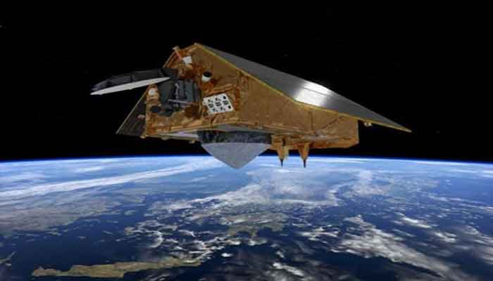
The first of two similar spacecraft, the second to be launched in five years, will be Sentinel-6a, which will have unparalleled precise measurements until at least 2030.
A radar altimeter is carried by each Sentinel-6 probe, which tracks the time it takes for radar pulses to pass back and forth to the Earth's surface.
The satellites will orbit the globe in the same orbit as previous missions that have provided data on sea-surface height over the past three decades, mapping every ten days 95 percent of the Earth's ice-free seas.
The pace of the increase of sea levels is arguably the effect of climate change that will affect the vast number of people over the next three decades.
Nearly 800 million people live within five metres of sea level, and even an increase in sea level of a few centimetres can translate into vastly more damage from high tides and storm surges.
– Sea level rise accelerating –
Already today, there are more than 100 million people living below high tide levels.
“Extreme sea level events that are historically rare — once per century in the recent past — are projected to occur frequently, at least once per year, at many locations by 2050,” especially in the tropics, the UN climate science advisory panel, the IPCC, concluded in a major report last year.
Satellites tracking the world’s oceans since 1993 show that global mean sea level has risen, on average, by over three millimetres (more than a tenth of an inch) annually.
More recently, that rate has increased to 5 mm per year.
“It is crucial that we are able to see these accelerations,” said Alain Ratier, outgoing Director-General of Europe’s meteorological satellite agency, EUMETSAT.
China, India, Vietnam, Indonesia and Thailand are home to the highest number of people living on land today, which by 2100 may be affected by permanent floods.
By the end of the century, the IPCC predicts a spike in the global rise in sea level of up to 1.1 meters (43 inches).
The Copernicus Sentinel-6 mission is a collaboration of the European Commission, the European Space Agency (ESA), EUMETSAT, NASA and the US National Oceanic and Atmospheric Administration (NOAA).
The Sentinel satellites are each about the size and shape of a large minivan topped with slanted solar panels, and weigh nearly 1,200 kilos (2,600 pounds), including rocket fuel.
They are designed to last for five-and-a-half years, but could provide data for far longer.